SSI Groundwater Monitoring Pilot Project Update

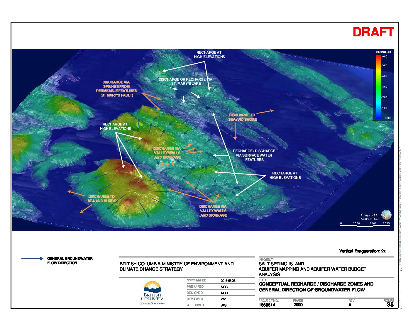
As recommended by Golder Associates in their recent public presentation on Salt Spring Island (November 23, 2018) “Groundwater Budget Analysis for Aquifers on Salt Spring Island, BC”: analyses, conclusions, decision-making and planning for freshwater sustainability on Salt Spring Island could really benefit from groundwater level monitoring and study of groundwater-surface interactions which have previously been sparse and under-studied.

During the two-year project by Golder Associates for both the provincial Ministry of Environment and Climate Change Strategy (ENV) and the Ministry of Forests, Lands, Natural Resource Operations and Rural Development (FLNR), a project was launched through a coordinated approach at SSIWPA and is co-lead by Islands Trust and FLNR: The SSI Groundwater Wells Monitoring Pilot Project.

Click the link at the project title above to see the updated information about this important pilot to collect and analyze 12 months of data and potential to continue as a community groundwater monitoring network to complement the Provincial Groundwater Observation Wells monitoring network.

SSI Groundwater Budget Analysis – Postponed

Monthly Groundwater Budget Analysis for Aquifers on Salt Spring Island

by Golder Associates (Jill Sacré, Nick Gorski and Willy Zawadski)

Please be alerted: This event has been postponed.

(postponement effective May 1, 2018)

Stay tuned here for new date to be announced!

The final results of a two-phase study by Golder Associates, consultants for B.C. Ministry of Environment and Climate Change Strategy and B.C. Ministry of Forests, Lands, Natural Resource Operations and Rural Development will be presented.

Everyone is welcome. Refreshments will be served.

Abstract:

Water supply for Salt Spring Island’s 10,000 residents and an estimated 10,000 annual visitors is derived entirely from the Island’s footprint, from community systems utilizing water from surface water and groundwater sources, together with private wells. Aquifer mapping for Salt Spring Island was conducted by integrating available geological mapping and information from over 2500 well logs using three-dimensional visualization software.

Monthly groundwater budgets were then derived for each aquifer to assess the sustainability of groundwater withdrawals based on available climate data, estimates of groundwater recharge, and an estimate of groundwater demand from domestic, commercial and agricultural users. The results of the budget analysis will be used to inform groundwater licensing decisions by the BC Ministry of Forests, Lands, Natural Resource Operations and Rural Development under the Water Sustainability Act, and to support water management initiatives being undertaken by local authorities and community groups.


This forms one in a series of Community Watershed Stewardship Presentations by Salt Spring Island Watershed Protection Alliance (SSIWPA).

Information about SSIWPA is here.